30.8.-9.1.2002

    Hochkönig West-Ost Überschreitung

    Salzburg

    Bergwanderung

    privat

     Tourenbeschreibung  GPS-Daten/Karten 


    zurück

    sh_hochkoenig_200208_100_NC.jpg
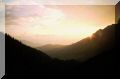
    Abmarsch in Hintertal

    sh_hochkoenig_200208_101_NC.jpg

    sh_hochkoenig_200208_102_NC.jpg

    sh_hochkoenig_200208_104_NC.jpg
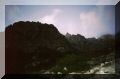
    Aufstieg zur Bertgenhütte

    sh_hochkoenig_200208_105_NC.jpg
    Bertgenhütte in Sicht

    sh_hochkoenig_200208_106_NC.jpg
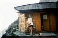
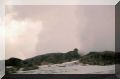
    Die Quelle bei der Bertgenhütte

    sh_hochkoenig_200208_108_NC.jpg
    Der leere Dosenmüll wird verkleinert

    sh_hochkoenig_200208_109_NC.jpg
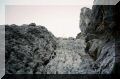
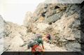
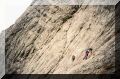
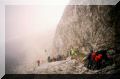
    Aufstieg zu den Teufelslöchern

    sh_hochkoenig_200208_110_NC.jpg

    sh_hochkoenig_200208_111_NC.jpg
    Schwierigkeit 2-, aber versichert
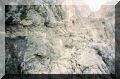
    sh_hochkoenig_200208_112_NC.jpg

    sh_hochkoenig_200208_113_NC.jpg

    sh_hochkoenig_200208_114_NC.jpgTeufels-
    löcher

    sh_hochkoenig_200208_120_NC.jpg
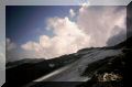
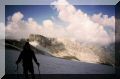
    Übergossene Alm, Matrashaus in Sicht

    sh_hochkoenig_200208_121_NC.jpg

    sh_hochkoenig_200208_122_NC.jpg
    Matrashaus

    sh_hochkoenig_200208_123_NC.jpg

    sh_hochkoenig_200208_125_NC.jpg

    sh_hochkoenig_200208_128_NC.jpg

    sh_hochkoenig_200208_129_NC.jpg

    sh_hochkoenig_200208_130_NC.jpg

    sh_hochkoenig_200208_131_NC.jpg

    sh_hochkoenig_200208_133_NC.jpg
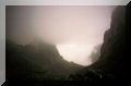
    Schlüsselstelle beim Abstieg zur Mitterfeldalm

    sh_hochkoenig_200208_134_NC.jpg

    sh_hochkoenig_200208_135_NC.jpg
    Links im Bild, die Torlsäule